Using a topographical map to find symbols in the land
Note: Read the post at https://walkingtheland.net/walking-the-land-sedona-arizona-vultee-arch/ as a reference and use it to follow along in this blog post.

Finding Symbols
When you walk the land, it means you are sensitive in all ways that you are. Sometimes, a landmass will look like something you easily recognize. For example, a human head in profile. Or perhaps of an animal or bird.
I always feel lucky as I hike into an area, if I see something that is part of a tree and I spot a symbol in it, or perhaps a mushroom or flower ring in the grass, or if in hilly or mountains, to see something in the soils and stones where you walk.
Finding a symbol is an exciting moment because it will tell you what kind of energy is in the area you trod. For example, if I see a bear in a scree slope, then I know this is bear energy, which is healing. The bear is considered the most powerful medicine/healer for Native Americans on “Turtle Island” (North American continent).
I would stop, take several photos of it, sit down with my journal, pull out my ink pen and colored pencils, and draw it. The reason I did that was to connect fully with the image I saw. That is forging a conscious link: your energy with the energy of the bear you see on the scree slope. Sometimes, it will “talk” to me (telepathy) and other times, not. But I do note it for the area and continue my hike.
Since we aren’t aerial drones and can’t lift into the air to look down at where we’re at, there is another ‘tool’ in your arsenal that is incredibly helpful to you. It is called a topographical (topo) map. I recommend you get a 1:24,000 scale map. You can get the maps online at the USGS website as a download or you can order a paper topo map from their store. If you are in the vicinity of a US Forest Service HQ, they often will have topo maps around the area.
Why are topo maps important?
When you look at one, it seems like constant thin or thick lines. Or you might think it looks like an abstract drawing. Make sure you get the topo map for the area you are going to hike. It provides you with a map of the terrain and can help you to see the layers that are hidden to most people, peeling them back to understand the energy in the area and its focus is.
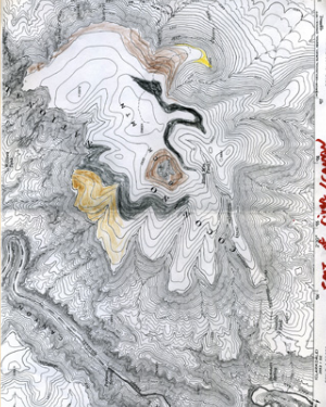
If you go to the Vultee Arch URL at the beginning of the blog, you’ll see that Marchiene Reinstra, my friend and hiking buddy and I, got a map of the area near Vultee Arch. All those lines, if you’ll relax your eyes, and look at it as if it is a jigsaw puzzle of sorts, you can see how the lines create animals, reptiles, amphibians, and even mythical beings. If you read the Walking the Land blogs for Vultee Arch, which include the 1:24,000 topo map of the area and what we saw in it, you’ll start getting an idea of how to look at one.
For some of you, you’ll instantly see faces, animals, mythic beings while the rest of us look and see nothing. Don’t stare so hard at it that it becomes frustrating. If you don’t see anything, leave it, break the energy, and do something else and come back and look at it once again. Eventually, you’ll see something that reminds you of more than just a set of contour lines. It would help if you outlined it with a fine, black Sharpie pen.
For example, the Vultee Arch topo map, if you look at it, do you see anything? I instantly saw a dragon or a snake with its tongue out, smelling the air. Do you see it? If not, scroll down a bit more on this blog, and you’ll see what I outlined in red ink pen. For me, it was a dragon. It FELT like a dragon. However, Marchiene felt it was a rattlesnake, which we have many of where we hike!
I also saw a vulture (also outlined on the topo map above and to the left of the dragon). Vultures are about dying, rebirth, and carrying the soul across the Rainbow Bridge to the Light (Heaven for some of you, depending upon your belief system).
It also pays to know the history of an area that you’re hiking. There is a Stinson Reliant SR-9C crash site of Gerard “Jerry” Freebairn Vultee and Sylvia Vultee located in Sedona, Arizona, in 1938.
Both husband and wife died in that crash. I wondered if the vulture in the topo map was an alert that life/death/rebirth energy was in the area. I was sure it was. Know your history of the area…whether Native American legends, area history, or books written by locals can help you find vital information that you’ll be able to double-check with your topo map.
Homework
Here’s an assignment for you, buy a topo map of where you live right now. Check out all the elevation lines on a 1:24,000 map. What do you see in it? Outline it. Think and feel your way through the symbol you’ve just discovered. Do more detective work and find out the history of the symbol location on your map. Once you’ve done all your homework, if possible, visit the area. Feel the energy and write or draw your impressions in to your journal.


