Walking the Land: Ordering Topographical Maps and Finding Symbols in Your Local Landscape
Did you know that based on where you live, there is a symbol(s) attached to the geography and geology of the land itself? This symbol tells us something about the area and the energy being sent out to all of us—and what is influencing us daily. In order to discover what it is, one has to look at it from a different slant.
To begin, you will need a topographical map of the area where you live (the state, county and town): a 7.5-minute quadrangle contour map with a scale of 1:24,000. In the lower right hand corner will be the name of the place (for example: Sedona, Arizona). These maps can be ordered for between $8-15.00 USD, from the website provided at the end of this article.
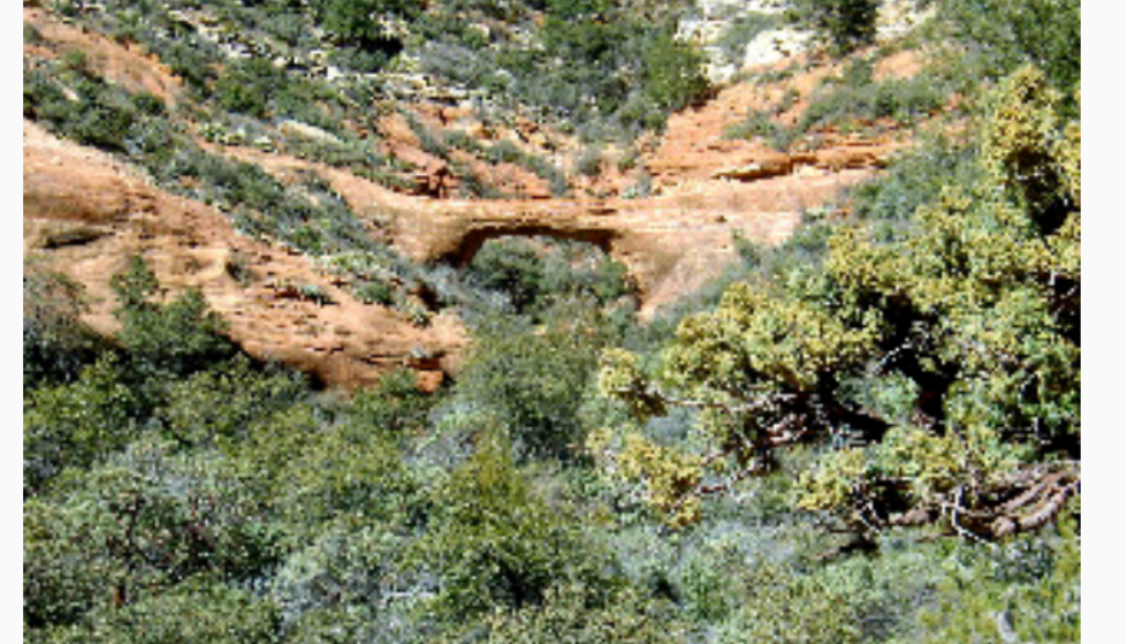
For this blog, we bought a 1:24,000 of the Vultee Arch area because we wanted to know whether we saw anything in the geographical landscape…and we did! And what a “double check” it turned out to be!
When you see something in a topo map such as a symbol or picture of some sort, the next step is to verify it, if possible. Usually, there is an event surrounding it, such as early pioneer settler or Native American stories of the area. I do a lot of research in bookstores in Sedona for books written by people who actually live in the area who have dug up the research on the stories and myths that wouldn’t be commonly known on a larger scale. These stories are nuggets of information that will show and tell about the area where you’re located.
For example, here’s one event that took place, and why the red sandstone bridge was named Vultee Arch:
Sedona’s Vultee Arch serves as a stunning memorial to an aviation pioneer
By SETH MULLER
Sun Staff Reporter Sep 10, 2003
For hard-core aviation buffs, the red-rock span known as Vultee Arch in Sedona serves as a shrine.
The arch is not far from the plane crash site where Gerard “Jerry” Vultee and his wife, Sylvia, lost their lives on Jan. 29, 1938. Vultee has been described as the Henry Ford of the plane industry.
With his slogan, “Build them fast and build them simple,” he designed the all-speed, all-metal V1 single-engine plane in 1932. He went on to design planes like the BT-13, which would be flown in World War II.
Vultee Arch is a good fit as a natural memorial to an aviation pioneer. From the top, it appears like the wing of an aircraft. And anything resembling a bridge offers a symbolic meaning of accomplishment.
WALKING THE LAND OBSERVATIONS:
In my notes on the plane crash story in the area, I put:
- plane crash/fire
- people killed
There are other stories, but I’ll bypass them for now because this one story encapsulates the two symbols Marchiene Van Reinstra, my hiking and walking the land partner, and I saw in the topo map (see graphic below):
- a fire dragon: dragons are a metaphor for transformation. Two people who were living, died in that airplane crash.
- a vulture: vultures are symbol of death and rebirth. These two people who were alive, died and that was their transformation.
Fire dragons cause FIRE: perhaps a wildfire; a crash (auto or plane) of some sort; or someone building a fire (not allowed by the USFS in our area) that goes out of control, causing a major burn in the area/wildfire.
The Kundalini energy we all possess is also “fire”, symbolically or as a metaphor, and this would be a good place to meditate and possibly experience the rising of the Kundalini energy
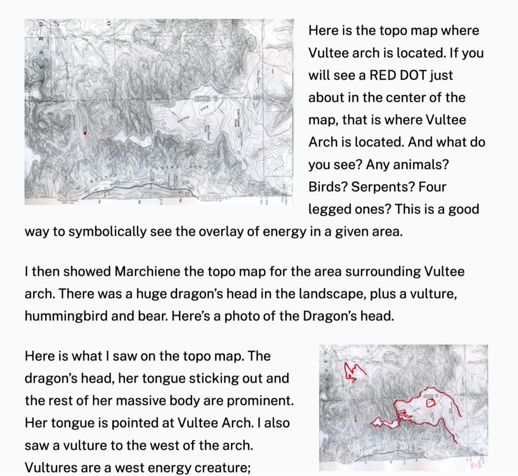
My analysis of the topo map with the story of the Vultee plane crash proved to me, without a doubt, that the animals seen in the topo map, brought about by the geology of the land itself, fit. This is just a small example of how you can use your local topo 1:24,0000 map to discover what you see in the lines and contours of it.
To read the original blog on Vultee Arch, go here:
https://walkingtheland.net/walking-the-land-sedona-arizona-vultee-arch/
I would love to hear from anyone who tries out this method of walking the land!
Check out my other topo instructive blogs:
https://walkingtheland.net/using-a-topographical-map-to-find-symbols-in-the-land/
https://walkingtheland.net/walking-the-land-sedona-arizona-vultee-arch/
HOW TO GET A MAP!
Where to buy topo maps in the U.S.A. – in my opinion, can be somewhat complicated depending upon your geekiness and age. Some of you will sail through this, and others, won’t. I’m giving you 3 ways to get the contour topo map you want. Be assured, if the first and second ways don’t work for you, there is a phone number where you can call and talk to someone who knows how to get the map you want.
1st way USGS store:
I don’t have much success with this method using the filters. You want to order 7.5-minute map topo contour quadrangle map. For example, you put in the city and state where you want this map from.
2nd (best way) Map-Locator:
https://store.usgs.gov/map-locator
For example, you put in the city and state of the location you want. I used Sedona, AZ (see graphics below)
There’s a GREAT VIDEO available on this method to explain everything. And most people will have success with this method. I always leave the entire year-span (in this case 1923-2018). Go to Map Scale, click on it and you will highlight 1:24,000. Below will appear in a box, the map(s) available to you. REMEMBER: if you click on PDF? It is FREE and will automatically download to your device. Otherwise, you will be buying a paper map for anywhere between (usually) $8-15.00. I always buy the paper map because I have it on hand here at home where I can look at the contour lines anywhere within that quadrangle to see if I see a symbol or animal in the geology landscape. You can do it online with a PDF, but getting them printed out can be a pain (in my experience…it may not be for you). The printer does not have the capacity to print the ENTIRE map. Just a small portion of it. Watch the below video for excellent and simple, straight-forward way to get the map you want:
USGS STORE VIDEO:
https://www.youtube.com/watch?v=QtRM9dGF2To&list=PLIxlFowAfHBAzSIeg7wszuUVsLzVkspQN&index=98
Graphic examples:
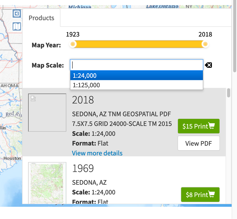
I like using the map locator function (#2 below). There’s also a video with it to explain how to use it. Here on the right side of the map locator for Sedona, Arizona, is a box that contains all the maps that are available to you. Also, it gives the year that the map was created. In this case, the one I want is the 2018 7.5 grid 24,000-scales map. You have two choices: either to buy the paper print one for $15.00 OR, you can get a FREE PDF download to your device. I always buy the map because I can refer to it here at home and see the “whole picture”; whereas if you try to print out the PDF version? It will only give you about 1/10th of the quadrangle map. So, it’s up to you.
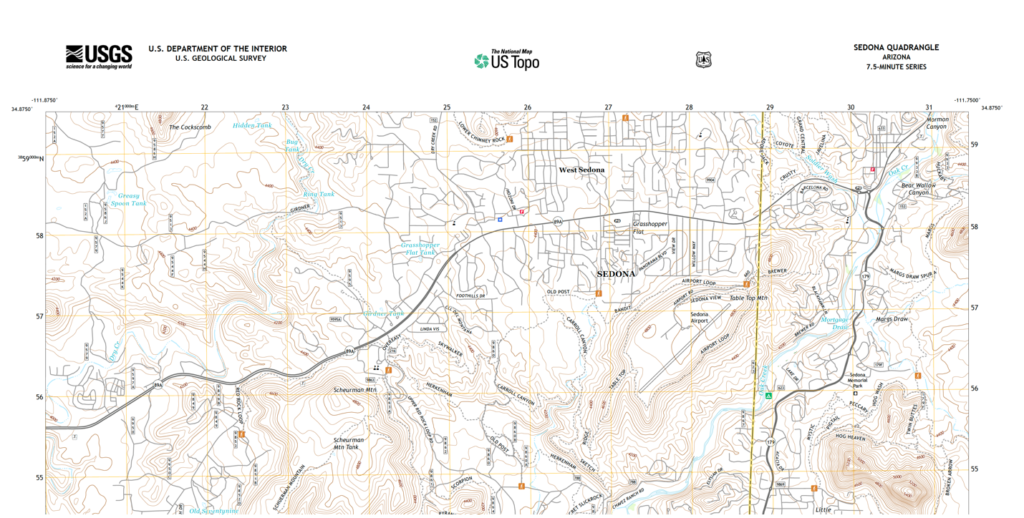
A partial example of the above map of Sedona, AZ. What do you see in the contours of the map? I see a turtle! Do you?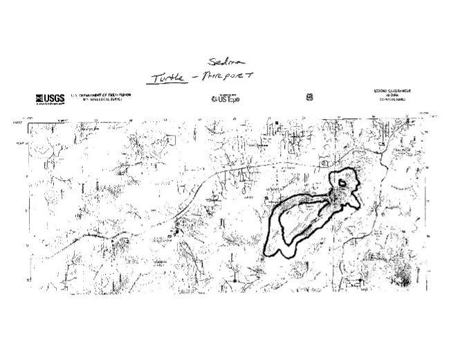 Here I’ve drawn what I see….a turtle that is part of the Sedona airport! Do you see it’s form/shape in the contour lines? Some people will see it, others won’t. It’s a right hemisphere of the brain function. And practice makes perfect. In time, you’ll see symbols or animals in the topo maps, too.
3rd way: CALL THEM at (888) 275-8747, option 3:
You need to tell them that you want the following:
7.5-minute map topo contour quadrangle map
Usually the contours are 40 feet apart, which is common for this type of map and works fine.
Tell them the location of the map you want. If it is where you live, then give the city and state
If it is for another area, give them that info (and if it’s a park or some other location, they can help you track it down, but try to have as much info as possible to where it is located). They can give you the URL where you can view it. Don’t forget: the PDF download version is FREE. If you want a paper map delivered to you via US Mail, it may cost between $8-15.00. I always buy the paper map so I can refer to them any time I want here at home when I’m looking for symbols or animals in the geology of the area.
